
We finally did it- we wandered far enough north to catch the sparkle of life in Michigan's Upper Peninsula.
Sprinkles of showers hit our greasy windshield as we pulled east out of our driveway in Ann Arbor. Our first destination was to be Bob's Yurt, the infamous grounds for many a sledder during Michigan's wet, northern winters. We've spent many a morning with the legendary Bob, sipping dark coffee and chowing dense, moist hotcakes made by Josh in preparation for a day of drywalling. After a week of drywalling with Bob, we jotted down a few obtuse directions and targeted ourselves onto the interstate towards this structure that we had spent hours discussing. Four hours into our drive, intermittently napping, singing, and chatting, we find ourselves crawling on the blacktop at 30 miles per hour, rain being our culprit. We are only miles from our beckoning exit, but realize that while it's pouring a couple mile hike into an unknown, slightly sketchy structure with our homes on our backs might not be an ideal beginning to our vacation.
So on to plan B. Further north is a completely different land mass, one that we've never tread upon. And it summoned us. We had heard of fudge shops and masses of water existing only 60 miles north of where we presently were, so our thoughts were to travel there, look for a weather radar, gorge on a bit of chocolate, and forge ahead. Reaching Mackinaw City we were greeted by the Mackinac Bridge, a structure that manipulates your being, immediately narrowing your physical self into a miniatured version of form. It creeps along the width of water between Michigan's two land masses, crystals of water lapping against its weighted outline. Stepping out of our moving machine, we brought ourselves to the waters edge, sandy toes chilled and degrees of awe bumping up on our skin. Not being from water, the two of us were a sight, snapping pictures, laughing, and wondering what in the world we were to do with all this wetness around. Rain slipped behind our ears, our rainjackets drooped on our icy shoulders, and our eyes were slits against the water that fell. And at our feet was a body of water dividing this state we'd been occupying for over four years yet had never known.
We crossed this bridge, found a Visitor's Center to guide our wayward journey, and saw that all around us was rain. But there was hope in the northwest. Not far out of St. Ignace, the town the bridge led us to, we were greeted by clearer skies and Lake Michigan to our south. We traveled along highway 2 with the intention of finding Pictured Rocks National Lakeshore and setting up camp. A couple of hours later, night threatening to come, we found ourselves in Grand Marais, the northern tip of the National Lakeshore, buckets of rain cascading down the sides of our Little Honda. A hopeless situation with no hostels in site.
Time for Plan C (or was it D?). Onto the Buckhorn Resort, an hours trek south. This meant backtracking. We wondered why we saw few signs of human life until our route took us to washboard roads, our bums hopping up in down in our foam seats, an encore of rain slapping the exterior. A day of driving in the rain and we both knew we were lucky to still like each other. But we pulled through, found the Buckhorn Resort, and realized it was little more than a storage barn.
Plan D (possibly E): On the way to our storage unit ("resort"), we had passed a sign leading to Otter Lake Campground. Driving in the depths of the forest we found a bin of firewood for sale and stuck a damp $5 bill in the cash register coffecan. Loaded with splintering wood and fingers crossed we drove along the dirt road to the campground. Now the air hung with water, but little actually fell from the sky. Otter Lake had a cloud of steam rising from it's belly. We were thrilled. This was adequate housing. Knowing that the wetness breathing down on us could at any point spill over it's sides, we worked quickly to make a fire and set up our tent. Darkness set in all around us, thoroughly covering our faces, our belongings, and all that was familiar. Leaning into the fire, we kept ourselves awake with the delicious smell of homemade, roasting potatoes Josh had prepared. Complete gratification.
I woke to the sound of small pelts of rain on our shelter and the sounds of wood chopping. Josh made a fire in the light rain that fell and we slurped our coffee true to good form. An hour later we were drenched, dripping in 40 degree rain and huddling next to our struggling fire. We realized the desperate situation we were in. Being the only people in the entire campsite, we out loud allowed ourselves to vent our extremes- laughing and wanting to cry all at the same time. The campsite, tho, had a bathroom. Little did we know that the bathroom actually had a shower until in desperation I ran across through the grounds to the edge of the water to where the bathroom structure sat. A hot shower wearing my flipflops never felt so good. It was a lottery win of such great proportions.
The weather didn't seem to want to let up, so we folded our wet tent into the back of the car, threw in our belongings, and cranked on the heat. We drove into the town of Munisey and decided to continue our drive on Highway 2, going into Marquette, MI. The town is built on water culture, fresh fish and boats all around. We spent time in the quaint town shooting photos, walking through their food co-op, and stopping into a brewery.
The rain hid itself in the afternoon hours so with great ambition we headed back towards Munisey, curious as to where the night would take us. It led to Lake Superior. We found 12 Mile Campground, an unimaginable scape of land in forest and sand and water. The wind wailed, a sure fire way to dry a soggy tent. After setting up camp, the Lake sprawling and lapping loud waves just beyond us, we decided to take an evening hike. We were headed towards a lighthouse- the lake on our left, the woods on our right. It was phenomenal.
We slept to the sound of the water and the wind. We woke up to chilly air and our coffee pot begging to be set on a fire. And the pictures that follow here are from an amazing 10 mile hike up and down land and water. Few people braving the weather led to almost completely desolate hikes, campsites, and roads. The trip can never be repeated. It was truly gorgeous, unexpected, and amazing.
Monday, June 11, 2007
Sunday, June 10, 2007
Pictured Rocks National Lakeshore

Mackinac Bridge- This bridge celebrates it's 50th anniversary this year, and is the access between Michigan's upper penninsula and lower state.


These five pictures were from our campsite the second night of our rustic stay in Pictured Rocks. We were right on Lake Superior. The wind was raging and the waves emphatically spilled onto the shore just feet below us. We had to make wind blocks for our campfire so as to slow the burning of our precious wood.


After establishing our campsite and setting up our tent to dry from the previous night's downpour, we set off on a three mile round-trip hike. We were chaperoned by unfamiliar plants and hiding moose (I really want to believe a moose was in those woods, completely enthralled by our every footstep), and serenaded by thunder. We found historical remains of shipwrecks (pics below), and this lighthouse, insinuating an aura of lake times past. This lighthouse was placed at this point as a means to slow the wreaking of ships- a tragedy that occurred far too often at that point in time- as they traveled from Whitefish Point to Munisey. The only way in is by foot now, and we were the only ones harebrained enough to brave the cold, threatening weather. That's the beauty of adventure.


And finally, a pictured rock....

Chapel Rock to Mosquito Falls

On the third day of our adventure there was a reprieve from the rain. The clouds made way for a beautiful, pastel sunrise, and the wind spurred our morning along by encouraging our fire to brew a quicker cup of coffee. We set out around noon on a 10 mile hike (which happens to be part of the North Country Trail that leads from New York to North Dakota) that would wind us around beach and forest, sand and loamy soil, waterfalls and plateaus. We caught sight of a kingfisher, an army of chipmunks, a mink, and yet again the quiet, hiding moose that we never could catch site. One of the first stops on the hike, only accessible by trail, was Chapel Rock. The site of this tree, perched on a massive form of rock, gazing out among the water with it's roots stretched across open sky is breathtaking and exhilarating. The ability of plants and trees to reach for life in adverse situations should remind us all to be extra thankful for their endurance. Without such survival techniques on the part of plant and animal life, our outlook on human existence might be even graver yet. Respect that of which we are the caretaker.


The Great Lake Superior....

These are the Pictured Rocks. We saw a sailboat glide by in the distance and it was from these rocks that many a seagull and the kingfisher floated overhead. Sitting there I wished that I, too, could fly, catching the wind on my wings and diving into the cold water for food....


Marquette
Marquette is the home of Northern Michigan University and was not at all on our roadmap for the trip. We ended up there after our multiple attempts to enter Pictured Rocks were thwarted by literal downpours. And yes, we did find a local brewery that sympathized with our chilled bones and hungry bellies.

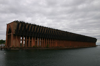
Josh was awed by this enormous concrete structure, stained rust from iron.


Josh was awed by this enormous concrete structure, stained rust from iron.

Subscribe to:
Posts (Atom)
